Thursday, March 11, 2010
The Philippines, is an archipelagic country located in Southeast Asia with Manila as its capital city. The Philippine archipelago comprises 7,107 islands in the western Pacific Ocean. Modern Filipino culture, though primarily Asian, has many more influences from the Western world than other nearby Asian cultures who have been able to retain more of their core Asian identity. Most of these influences are a product of previous colonization and derived mainly from the cultures of Spain and the United States, with a secondary influence from Latin American cultures who were under Spain during the same period the Philippines was. The influence from the United States being so strong that the Philippines continues to integrate newer American cultural influences into its culture even in this post-colonial period. Tourism plays an important role in the Philippine economy. In the year 2000, net tourism income in the Philippine totaled to 2.1 billion U.S. dollars. Most of the foreign tourists came from the United States, Japan, South Korea, Hong Kong, New Zealand, and The Netherlands. There were also tourists coming from Taiwan, Australia, Great Britain, Germany, Canada, Israel, Russia, France and Singapore. Labels: Beauty Tourism, Countries Tourism, World Tourist Spots, World travel tourism, World wide tourism
Monday, March 8, 2010
About 56km off the coast of Pahang lies Tioman Island, an alluring holiday paradise in the South China Sea. Acclaimed as one of the best island getaways in the world, Tioman was the location of the Hollywood musical, ' South Pacific' in 1959. According to legend, this island is the final resting place of a mythical dragon princess. The warm waters and good visibility make Tioman a paradise for divers. Discover astounding sights such as colourful Gorgonian sea fans, Staghorn corals, nudibranchs and beautifully sculptured sea sponges. Snorkellers can delight in swimming alongside huge Napoleon Wrasse, Golden Striped Trevally, Bumphead Parrotfish and shoals of Fusiliers. This island is an idyllic spot for leisurely days under the sun. Swim in its emerald waters, enjoy a stroll by the beach or be lulled to sleep by the sound of the waves. There are several villages scattered around the coastline, the larger ones being Salang, Tekek, Genting, Paya and Juara. The island's granite formations make for excellent rock-climbing expeditions. The more adventurous can attempt to scale the sheer cliff face of the legendary Gunung Nenek Semukut or Dragons Horns. Berjaya Tioman Beach, Golf & Spa Resort offers a luxurious stay amidst a backdrop of rolling hills and scenic views. Labels: Beauty Tourism, China tourism, World Festival Tour, World Tourist Spots, World travel tourism
Sunday, January 17, 2010
Brunei should host new international sports events as one mode of putting the country on the world tourism map, said sports supporters, after the three-day Asia vs Europe 9-Ball Team face up to attracted hundreds of visitors to the Rizqun International Hotel. Lee Han Wee said that he liked every international sports competition seized in the Sultanate as it gives admirers such as him an option to witness a live match. "Its high moment we prove to the globe that Brunei can host international tournaments such as this, and we require doing this extra in order to put us on the plan. I consider this is one of several ways to improve tourism in the Sultanate," he told The Brunei Times. "It's an excitement to actually be capable to observe a 9-ball game up close quite than on television. You truly catch the experience of it. I expect to see more of this being organized so that my age group and I can enjoy," he added. One of the practical staff at the hotel said many viewers showed up early to observe their favorite’s players in act. "As estimated, there are more turnouts of viewers today than the earlier two days. Not just because it’s the finals, however it's also a Sunday when public are not at work," he said. "Crowds go wild with cheers as Asian players' names were declare by the emcee, and that actually proved the strength and support of the local viewers," he added. Labels: Countries Tourism, Information tourism, Tourism, World Tourism, World Tourist Spots, World Vacation
Wednesday, January 6, 2010
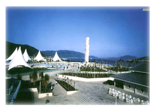 China China plans to expand the southern island of Hainan, China's only tropical region, into a top international tourism destination by 2020, according to a declaration released by the State Council Monday. Also, the government aims to expand Hainan into a platform for international economic collaboration and cultural relations, a base for agricultural production and increasing resources and services in the South China Sea. The government encourages developers to put up premium hotels and resorts in Hainan. Meanwhile, family-operated hotels and property-rental services will be confident, according to the declaration. There will also be an importance on the growth of the financial industry in the island. China will expand its yuan trade completion test program to Hainan Province and promote qualified tourism firms there to register on the stock market. The government also launched other actions to boost the island's expansion, including rising oil and gas exploration, contributing more duty-free services, falling pollution and building new information networks and transportation. The plan also includes events to uphold modern tropical agriculture in Hainan, including tropical fruits and aquatic products, and enlarge its agricultural cooperation with Taiwan. Hainan is a admired holiday destination among domestic travelers and some foreign tourists. In 2007 there were 18 million domestic tourists, and 750,000 from out of the country. Labels: Beauty Tourism, China tourism, Countries Tourism, World Festival Tour, World Tourist Spots, World travel tourism
Thursday, December 3, 2009
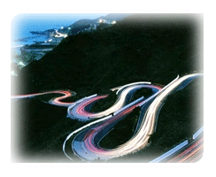 Ruifang Ruifang Township is a renowned township of Taiwan’s northeast. It is known for its roots in the mining industry, which gradually evolved into other industries. Jiufeng, a part of Ruifang, was Taiwan’s gold mining center in the past. It is a small mountain village with ever changing scenery of both mountain and sea that still retains the simple lifestyle of the past. In 1893, gold dust was discovered in the surrounding area, drawing a river of gold seekers into Jiufeng and launching Taiwan’s own gold rush. By the end of the second world war, following Taiwan’s independence from Japan, the gold rush had diminished and the crowds began to scatter, finally coming to an end in 1971. Jiufeng has become a place where the busy urban dweller can finally find a place to relax his or her mind. Jiufeng is located on a hilly area that faces the ocean and is surrounded on three sides by mountains. It is a mountain colony stretching over high and low, with its people still maintaining their original simple lifestyle. Because the houses and buildings are built close together, residents interact frequently, lending this place a warm and rich human touch. With the changing of seasons, the scenery also varies greatly, presenting different aspects of Jiufeng. In the past, Jiufeng was the dreamland of gold diggers; as of now, it has become a sanctuary for many artists. Labels: Beauty Tourism, Countries Tourism, Taiwan Tourism, World Holiday tour, World Tourist Spots
Tuesday, November 17, 2009
 Manila Cathedral Manila Cathedral is a magnificent architectural feat with its intricate stone carvings, stained glass mosaics, and rosette windows The Church of Manila was established by the secular Juan de Vivero who had the honor of baptizing Rajah Matanda. The Church of Our Lady of the Immaculate Conception administered the religious affairs of Manila until such time it became a parish and Manila was created into a diocese. It was a simple structure of nipa and bamboo, materials which were readily available during that time. It had for its first parish priest the secular Juan de Villanueva. The other religious who became the pillars of this parish were Juan de Vivaneta and Nicolas Riccio. Manila Cathedral is located near Beaterio; near Gen. Luna; near Cabildo; near Postigo; near Sto. Tomas; Manila Cathedral is geographically located at latitude (14.5915 degrees) 14° 35’ 29" North of the Equator and longitude (120.9738 degrees) 120° 58’ 25" East of the Prime Meridian on the Map of Manila. Labels: Beauty Tourism, Countries Tourism, World Festival Tour, World Tourism, World Tourist Spots
Wednesday, November 11, 2009
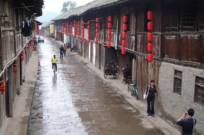 Xilai Ancient Town situated in the northern part of the county has a history more than 1700 years.it is 66 kilometers away from Chengdu and 13 kilometers from the county. There are typical residential housing in West Sichuan, thousand-years aged banyan, beautiful river corridor and fascinating rustic scenery. After recent years' construction, the ancient town has finished the sight-formation , culture excavation of the core area and outer-ring supplementary construction and has formed the cultural theme of "mountain and water coming from the west and ancient town represented by writing and painting".The town has also perfected the reception services and was opened up on New Year's day in 2007.The scenery has successfully set up the town as one of the " Top 10 Glamourous Town", " Historically and Culturally Renowned Town" and " National town with Beautiful environment". Labels: Beauty Tourism, Countries Tourism, Information tourism, World Holiday tour, World Tourist Spots
Monday, November 2, 2009
The Andes mountain range shows its beauty in the Patagonian provinces. Millennial silent forests with native vegetable species are extended along the shores of glistening waters. On top of the mountains, nature overflows with granite peaks and ice fields spreading their glacier tongues into lakes of unsurpassable beauty.
Imposing mammals and sea birds, half-way between real life and fantasy, spend certain seasons on the rough coasts of Patagonia where they complete part of their life cycle. Seals colonies play on the islets and sandbanks. The world’s most important southern elephant seal continental colony is located in Peninsula Valdes. Every year, southern right whales come to Nuevo and San Jose gulfs to breed. Patagonian hares, “nandues” (South American ostrich) and “guanacos” run about the steppes, and the largest colony of Magellanic penguins in the world is located in Punta Tombo. This life cycle repeated since time immemorial, unfolds itself in front of the astonished visitors’ eyes.
In the south, Tierra del Fuego and the World’s southernmost city, Ushuaia, are the gateway towards the vast and mysterious Antarctica. Labels: Beauty Tourism, Countries Tourism, World Tourism, World Tourist Spots, World Vacation
Sunday, October 25, 2009
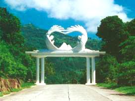 Known originally as Shuanglianku, Mount Zion was once an uninhabited, remote and desolate mountain located in Siaolin Village, in Jiasian Township, in Kaohsiung County. In 1963, God led Elijah Hong, Prophet of All Nations, to this mountain. In 1979, Elijah Hong was directed by God to settle down on Zion. From Zion, he brought forth the teachings of God. He also proclaimed, “God has forsaken Jerusalem in the Middle East. He has chosen Mount Zion in the Far East. Mount Zion in Siaolin as the mountain of the LORD’s house, as mentioned in the prophecy of Isaiah. All nations shall flow to this mountain on pilgrimage. They will come to worship the Great King of Zion!” Since then, saints from various parts of the world have begun coming to this mountain on pilgrimage. God’s chosen Mount Zion is located among the mountains that stretch across the counties of Kaohsiung, Tainan and Jiayi. It has a natural demarcation, and its terrain resembles a king’s throne. The trip to Mount Zion starts from Siaolin Village in Jiasian Township, Kaohsiung County. The road that leads to Mount Zion is Provincial Highway Tai 21, which runs alongside the Nanzihsian River. It takes about 10 minutes to drive to Bridge 12. By then, a towering retaining wall, an embankment, will be in sight. This majestic and impressive structure, 60 meters in height and more than 100 meters in length, is called Zion’s Stronghold. Now, here you are in Mount Zion. Labels: Beauty Tourism, Countries Tourism, Mount Zion, World Tourist Spots, World travel tourism
Friday, October 23, 2009
Morni is a tourist place in Morni Hills in Panchkula district of Haryana in India. Morni Hills are the offshoots of Shivalik range of the Himalayas, which run in two parallel ranges. The village of Morni (Bhoj Jabial) lies on the mountainside, at 1220 meters above mean sea level. Traditions assign the name of Morni to a Queen who is believed to have ruled this area. Among the spurs of hills, lie two lakes, the larger is about 550 meters long and 460 meters broad and the other about 365 meters either way. A hill divides the two lakes but there is some Hidden channel, as the level of two lakes remains the same. The people look upon the lakes as sacred. There is an old fort, which is now in ruins. The hills are covered by pine trees. The climate is salubrious and the area is suitable for trekking. The Haryana Government has developed this hill resort and provides facilities to tourists, a motorable road was constructed to connect the Morni hills with Haryana State Highway near Panchkula. A Forest Department rest house "Lal Munia" and a PWD rest house were also constructed to accommodate tourists and trackers. There are also small playgrounds for children. There is a roller skating rink and a swimming pool. It is an ideal place for tourists who want to avoid crowds and for those who love nature.There are a number of resorts that add to accommodation options and variability in and around Morni.It is a place that is frequented by nature starved people(whose tribe is ever growing in cities) on the weekends or holidays and it might be difficult to grab a decent meal at times in the high season.A decently stocked liquor vend and an attached snack shop that serves turmeric laden omelettes and toasted bread ,does for the meals to famished tourists. The best season to visit is September to March, because it might get hot or humid during the rest of the months and venturing might be overly-humid. It has 2 small man-made lakes called Tikkar Taal, bada tikkar and chota tikkar. Tikkar Taal offers good attraction for tourist and campers to frequent Morni. Campers accommodation in dormantories is made available by Haryana Tourism at Tikkar Taal. The road that descends from the zenith of the hillstation brings you to a seasonal waterfall that drops into a muddy lake but is aloof from crowds , so gives relaxation space and time .Further up the road takes you into Himachal pradesh.On the high point where the road forks for the steep descent for the twin lakes,at clear nights,especially after showers one can see the lights of chandigarh.The geometrically placed streetlights,neon or sodium vapour, & occasionally bright signboards, howsoever blurred tend to mesmerize you. There are three roads that connect Morni to chandigarh or other nearby towns(courtesy Haryana government), so one wont get stuck up in case of a blockade on any road, likely landslides in the rains.The town has grown so has time required to absorb the milleu and soak the nature and experience that it provides. Labels: India Tourism, Tourist spots, World Tourist Spots
Thursday, October 22, 2009
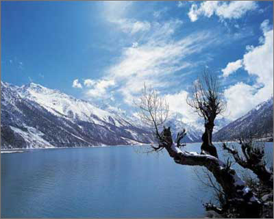 The Ranwu Lake is a perfect blending of the Swiss Alps snow peaks and glaciers and the streams in Jiuzaigou (a pretty town in central China). Just as depicted in the diary of Mr. Zhang Qingsong (a known professor from the School of Geography, Chinese Academy of Science who has set foot on all the three poles of the planet): “in my first journey to Tibet in 1975, I took a bus down the Sichuan-Tibet Highroad from Chendu to Lhasa. After passing the Henduan Moutain Range, the valleys of the Rivers of Jinsha, Lanchang and Lu, I stayed in the Ranwu Garrison overnight, the poetic scenery of the Ranwu Lake drove away all my fatigues. How amazing are those upright high peaks, white glacier, blue lake water, green grassland, floating white clouds, lush forest …” The Ranwu Lake, the largest in southeast of Tibet, is in the Village of Ran about 90 km from the Baiba Town neighboring the Nyingchi Prefecture. The lake, 3,800 meters above the sea level, has a water area of 22 square kilometers. On the bus ride from the Basu County, Chadu down the Sichuan-Tibet Highway (now the National Highway No. 318) one can see a corner of the lake. This is the most dangerous highroad in China. The Ranwu Lake is surrounded by many scenic highlights, e.g. the Gangrigabu Snow Mountain in the southwest, the Azhagongla Glacier in the south and the Bosula Peak in the northeast. The melted snow and ice supply the lake with sufficient water and are also the source of many rivers such as Yaluzhangbu. The green grassland around the lake, the sky-blue lake water and the white snow mountains constitute a very pretty watercolor. The Amucuo Lake shrinks westwards and finally became a river valley. Its water takes on different colors in different seasons of a year and the water surface is dotted with isles or reefs. Many of the peaks surrounding the lake are over 5, 000 meters high and thus permanently locked with glaciers. The foot of these peaks, however, is green with pines and cypresses. The lake is especially womanish and tranquil in the arms of the peaks, whose beauty goes beyond words. The browsing herds of cattle and sheep, the barley paddy, bean and cabbage field form an oil painting that can be seen no elsewhere. Labels: Beauty Tourism, Ranwu lake, World Tourism, World Tourist Spots, World travel tourism
Monday, October 19, 2009
 It boasts of the world's longest navigable underground river. This site is currently ranked number 8 on the list of New Seven Wonders of the World. The Puerto Princesa Subterranean River National Park is located about 50 km north of the city of Puerto Princesa, Palawan, Philippines. It features a limestone mountain landscape with an 8.2 km. navigable underground river. A distinguishing feature of the river is that it winds through a cave before flowing directly into the South China Sea. It includes major formations of stalactites and stalagmites, and several large chambers. The underground river is reputed to be the world's longest navigable. At the mouth of the cave, a clear lagoon is framed by ancient trees growing right to the water's edge. Monkeys, large monitor lizards, and squirrels find their niche on the beach near the cave. Labels: Puerto Princesa Subterranean River, Tourism attractions, Travel, World Tourism, World Tourist Spots
Thursday, October 15, 2009
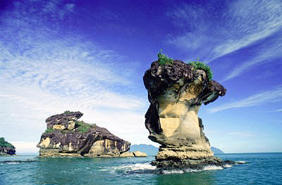 Sarawak's oldest national park was established in 1957, covers a modest 27 sq. km., and is about 37km from Kuching. It's known for its extraordinary natural scenery, habitats, plants and wild life. Its most significant features are secluded coves and rugged rocky headlands with magnificent steep cliffs that overlook the South China Sea. The sea spray, wave action and the wind have also carved out magnificent sea arches and sea stacks at the base of the cliffs, some rearing above the waves like a mighty serpent's head. The attractive sandstone formations appear pink with iron patterns on the cliff. Further inland, waterfalls tumble down into freshwater pools in a tranquil and idyllic jungle setting. Bako contains an incredible variety of plant species and vegetation types, and this is one of the park’s great attractions. At Bako it is possible to see almost every type of vegetation found in Borneo. Bako is also home to approximately 275 rare proboscis monkeys, found only in Borneo. The best times for seeing wildlife at Bako are just after dawn and just before dusk, when the animals are at their most active. Bako is a fascinating place for bird watching, as over 150 species have been recorded here. Bako’s extensive trail system is made up of 16 colour-coded jungle trails which offer a range of walking and hiking options. The fit and adventurous can opt for full-day jungle hikes or overnight camping expeditions, whilst those who prefer to take it easy can opt for a relaxing forest walk. Labels: Bako National Park, World Tourism, World Tourist Spots, World travel guide
|


