Friday, July 31, 2009
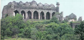
Gavilgarh fort is located on a 1103 metres high lower Satpuda range, now under the Melghat Tiger Project. It is 2.5kms south-east of Chikhaldara, a popular hill station, and about 30kms north of Achalpur, the old capital of Berar, now a taluka town. Gavilgarh took its name from the pastoral Gavalis who, centuries ago, had a mud fort on this hill. The new fort was built by Ahmad Shah Wali, the ninth king of Baharmani dynasty in 1425 AD, the fort was repaired and extended by Fateh-ullah Imad-ul-Mulk, the founder of Imadshahi in Berar.
Gavilgarh has two level, the outer fort being slightly lower than the inner one. This outer fort has a third wall which covers the approach to it from the north. The fort has two main gateways, the Delhi Darwaza, between the inner and outer fort, and the Fateh Darwaza, the south-western gate, built by Fateh-ullah Imad-ul-Mulk. The most conspicuous of the remains in the fort is the great mosque which stands upon the highest point towards the south side of the inner fort. Built in the Pathan style of architecture, the mosque has seven arches in its façade. Of the two minarets, the one at the north-eastern angle of the building still exists. Its square canopy, with very exquisite stone lattice-work, raises little above the domes of the mosque. There were not less than eight tanks in the fort, two of them still in good condition. There still remain in the fort several canons, the one at the southern end being the largest.
Gavilgarh has a long history. The saying was; “One who controls Gavilgarh, controls Berar.” After the split of the Bahamani Kingdom, it passed through many hands. It was with the Imadshahi in 1488 AD, the Nizamshahi in 1574 AD, the Mughals in 1599 AD and the Marathas in 1754 AD, before it fell to the British in 1803 AD. Gavilgarh was dismantled in 1858 AD lest it should be seized by Tatya Tope, who in that year attempted to break from the Satpuda hills into the Deccan in order to stir up the country for the independence movement.
Thursday, July 30, 2009
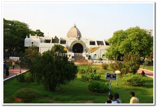 The monument to the poet-saint Tiruvalluvar is wrought like a temple chariot and is, in fact, the replica of the temple chariot in Thiruvarur. A life-size statue of the saint has been installed in the chariot which is 33m. Tall. The 133 chapter of his well-known work Thirukkural have been depict in bas-relief in the front hall corridors of the chariot. The auditorium at Valluvar Kottam is said to be the largest in Asia and can accommodate about 4000 people. It stands as a modern memorial to the great poet who represents the glorious culture of the Tamils.
Thirukkural, are emblazoned on the granite pillars that surround the auditorium and it has got no pillars for support. There is a 101-feet high temple chariot arrangement with a life-size image of the poet in it. This chariot is a replica of the temple car of Thiruvarur in Tamil Nadu. The base of the chariot shows in bas-relief the 133 chapters of the Thirukkural. Over 3,000 blocks of mineral were used to create this memorial to Tamil culture.
Wednesday, July 29, 2009
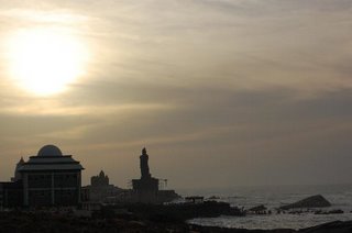 A well-liked tourist place in India, the town and the district, Kanyakumari District, in which it is located, is a place of great natural loveliness - from the blue seas of Kanyakumari town to the blue hills of the Western Ghats in the interior.
Kanyakumari take its name from the Kumari Amman or Kanyakumari Temple, located in the town, on the sea-shore, the very flowing together of the three water-bodies - Bay of Bengal, Indian Ocean and the Arabian Sea. In his work on ancient India, Ptolemy had identified Kanyakumari (Cape Comorin) along with the Gulf of Mannar as a centre for pearl fishery.
start the early part of the 1970s, sightseeing has been an important activity in the town. Of late, Tourism is increasingly being promoted in the district also, apart from the town, with several beautiful natural landscape, historic and spiritual places found around the region.
Though there are several places of tourist-interest in the town and region, Kanyakumari is especially well-liked in India for its spectacular and unique dawn and sunset. The confluence of three ocean bodies - the Bay of Bengal, the Indian Ocean, and the Arabian Sea - makes the sunrise and sunset even more special. On balmy, full-moon evenings, (locally called Chitra Pournami) one can also see the moon-rise and sunset at the same time - on either side of the prospect.
Monday, July 27, 2009
 Welcome to the metropolitan that never sleeps! Pulsating, Alive, On the Move, Vibrant, Fun -- this be Mumbai or as it is still repeatedly referred to -- Bombay. The most modern city in India, it captures the spirit of the changing pace set by liberalization and innovation. Once a cluster of seven islands, Mumbai was presented to King Charles II in 1661 as part of the dowry when he married Princess Catherine de Braganza of Portugal. Over the years, as colonialism gave way to independence, Mumbai has distorted itself into an entity with thriving markets, business houses and many dissimilar communities reflecting a cosmopolitan and trendy atmosphere rarely seen elsewhere. On the surface, it represents the ever-changing face of today's India -- the old coupled with the dynamic new, and yet at its very core, the heart of the city is steeped in Indian customs and values.
It is the capital of Maharashtra state, and its official speech is Marathi although English and Hindi are widely spoken and understood. The fast-paced life has given rise to hordes of "fast-food outlets" on almost every road, offering lip-smacking choices of Mumbai's very own pau bhaji, bhel puri and kababs. There is no dearth, though, of multi-culinary delicacies dished out in posh restaurants by expert chefs. Mumbai is a shopper's delight with bargain buys, exclusive boutiques, ethnic market and mini bazaar.
This busy city is also the hub of a thriving cultural life, with a constant stream of performances in music, dance and drama. The seat of the Hindi film industry, known locally as Bellwood, it produces the largest number of films in the world. Mumbai caters to the adventurous and the romantic through its sporting activities, nightclubs, pubs, theatres, beaches and restaurants. Old and new, rich and poor, classical and modern -- its all here for you to savour and enjoy!
Friday, July 24, 2009
Nongkhnum Island is the largest river island in Meghalaya and the second biggest river island in Asia, after Majuli Island in Assam. Located about 14 Kms from Nongstoin, the district hqs. of West Khasi Hills, it is 20 to 25 sq. kms in area. Travelling on foot from Nongstoin through the villages of Lawse, Mawduh and Mawthar, it takes about two and a half-hours to reach the Island. There is a wooden bridge over the Weinia Fall to enter the Island. The Island is formed by the bifurcation of Kynshi River into the Phanliang River and the Namliang River. At the point of divergence, there is a beautiful sandy shore about 100 sq. meters in area. The Phanliang River forms a beautiful lake adjacent to the sandy beach. This lake is about 400 to 500 sq. meters. The River then moves along and before reaching a deep gorge, forms a pretty fall about 60 meters high, called Shadthum Fall. At the bottom of the fall, there is a beautiful pool where a variety of fishes can be found. It then continues its journey and finally reunites with the Namliang River, near a place called Thongrin. The Namliang River first flows towards the north and then changes its course towards the west. It then reaches a gorge and forms two narrow falls. The first one is called Riatsohkhe fall and is near Mawthar village. The second one is the wonderful and beautiful Weinia fall, which is about 60 meters high. The River then flows further west till it reunites with the Phanliang River on the western rocky shore and then flow towards the west. After a distance of about 10 kms from the Island, it reaches the deepest gorge and forms the longest fall in the region of about 335 to 340 meters high, called Langshiang fall. The area surrounded by the two Rivers, i.e. Phanliang and Namliang forms the Nongkhnum Island. Within the Island, there are big trees and areas of grassland and natural playground suitable for playing football and golf and even for landing a helicopter. There are plenty of fishing pools, especially near the sandy shore, called Wei-Phanliang. Angling is the only way to enjoy as well as protect the fishes.
Monday, July 20, 2009
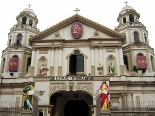 Quiapo Church, also known as the Minor Basilica of the Black Nazarene, is the site of the annual January Black Nazarene procession. One of Manila’s most famous churches, Quiapo Church gets very crowded every Friday when thousands of devotees come to light a candle in supplication to the Black Nazarene, a life-size image of Christ believed to be miraculous. Around the church is a fascinating gathering of vendors selling candles and curiosities like amulets and folk cures for obscure ailments. The present cream-colored edifice was built after the original Mexican Baroque structure burned to the ground in 1928. Quiapo is a district of Manila, Philippines, also referred to as the "old downtown". It is known for its cheap prices on items ranging from electronics, bicycles to native handicrafts. Quiapo is also famous for the Black Nazarene. Thousands of people parade through the streets to touch the statue where it is supposed to produce miraculous effects. A number of faithful usually collapse in a faint during the ritual, and some have even died. The Feast Day of the Black Nazarene (also known as Quiapo Day) is celebrated every January 9th. Plaza Miranda in the heart of Quiapo District, is named after Jose Sandino y Miranda, who served as secretary of the treasury of the Philippines for 10 years beginning in 1853. It is a square or a public plaza in front of the St. John the Baptist Church or Quiapo Church as it is widely known. It is also a popular site of political rallies. The Quiapo district is also home to a sizable Muslim population in Manila, and The Golden Mosque is located there. A veritable army of fortune tellers and stores offering herbal products surround the Quiapo church. The biggest problem underlying the district is piracy and bandits. The largest area where you can buy pirated movies, software and pornographic videos can be found in Quiapo where the stores sprawl over four public streets. Through the years, the glory of Quiapo steadily declined. During the American period until the late 70s, Quiapo and its surrounding vicinities like Avenida, Binondo, Sta. Cruz, Escolta and the university belt, were the centers of trade, fashion, art, higher learning and the elites of Manila, however as the Light Rail Transit (LRT Line 1) run over the Rizal Avenue, the main thoroughfare of Avenida, dirt and vehicle emissions were trapped underneath, leaving the streets dark and gloomy. The results of this development were the exodus of many establishments and the arrival of ruffians and bandits. After the People Power Revolution in 1986, the vibrancy of Quiapo diminished, although some flea markets, handicraft stores begin to rise due to the presence of the widely visited Quiapo Church. Quiapo is geographically located at the very center of the city of Manila. It is bounded by Estero de San Miguel on the South, San Miguel District on the East, Claro M. Recto Avenue on the North and Quezon Boulevard on the West.
 Intramuros, the old capital of Manila, was built in 1571. It remains a monumental, if ruined, relic of the Spanish period in Philippine history. It is a city within a city, separated from the rest of Manila by its crumbling walls. This ancient capital had well-planned streets, plazas, the Governor's Palace and churches. However, many buildings were reduced to shambles in World War II.
Among the places to visit in Intramuros are the two churches - The Manila Cathedral and St. Augustine Church -- and Fort Santiago. - The Manila Cathedral is the fifth stone church of Manila. It was destroyed and rebuilt several times. From the air, it appears as a giant cross.
- St. Augustine Church is the oldest stone church in the Philippines. It was built in 1599; however, it was also destroyed and rebuilt many times. It is an immense structure of thick walls of Corinthian and Ionic designs.
Fort Santiago used to be the seat of the colonial powers of both Spain and the U.S. It was also a dreaded prison under the Spanish regime and the scene of countless military police atrocities during the Japanes occupation. Here, too, Dr. Jose Rizal spent his last hours before his execution on Bagumbayan. (now Rizal Park).
Wednesday, July 8, 2009
Ward's Lake: Ward's Lake is century old picturesque lake also known as Polok Lake. Located in the heart of the city, popular for short garden walks and boating. The local people however prefer to call it Nan Polok (Polok's Lake) after an executive engineer named Mr. Pollock. It has a most pleasant, winding walk-a-way all around its parameter set in cobbled sand stones, in the midst of picturesque, rolling flower beds and fairyland lighting. The lake has a striking arched bridge over it.
|


 The monument to the poet-saint Tiruvalluvar is wrought like a temple chariot and is, in fact, the replica of the temple chariot in Thiruvarur. A life-size statue of the saint has been installed in the chariot which is 33m. Tall.

