Home ::Travel Destinations ::Kruger National Park
Kruger National Park
The Kruger National Park is one of the biggest game reserves in Africa. The Kruger National Park covers 18,989 square kilometres (7,332 sq mi) and extends 360 km (220 mi) from the north to south and 65 kilometres (40 mi) from east to west.
To the west and south of the Kruger National Park are the 2 South African provinces of Limpopo and Mpumalanga. In the north is the Zimbabwe, and to the east is the Mozambique. the Kruger National Park is now part of the Great Limpopo Transfrontier Park, a peace park that links Kruger National Park with the Gonarezhou National Park in Zimbabwe, and with the Limpopo National Park in Mozambique.
The Kruger National Park is part of the Kruger to Canyons Biosphere, an area designated by the United Nations Education and Scientific Organisation (UNESCO) as an International Man and Biosphere Reserve
The park has nine major gates that allow entrance to the different camps. The good names of these gates are Paul Kruger Gate, Numbi Gate, Malelane Gate, Crocodile Bridge Gate, Punda Maria Gate, Orpen Gate, Phalaborwa Gate, Phabeni Gate and Pafuri Gate.
The park is the site of the popular eyewitness viral video Battle at Kruger
The Kruger National Park lies in the north-east of South Africa,in the eastern parts of Limpopo and Mpumalanga provinces. Phalaborwa, Limpopo is the only town in South Africa that borders the Kruger National Park. It is one of the largest national parks in the world, with an area of almost 20,000 square kilometres (7,700 sq mi). The Kruger National Park is approximately 360 kilometres (220 mi) long, and has an average width of 65 kilometres (40 mi). At its widest point, the park is 90 kilometres (56 mi) wide from east to west. To the north and south of the park two rivers, the Limpopo and the Crocodile respectively, act as its natural boundaries. To the east the Lebombo Mountains separate it from Mozambique. Its western boundary runs parallel with this range, roughly 65 km distant. The park varies in altitude between 200 m in the east and 840 m in the south-west near Berg-en-Dal. The highest point in the park is here, a hill called Khandzalive. Several rivers run through the park from west to east, including the Sabie, Olifants, Crocodile, Letaba, Luvuvhu and Limpopo rivers
The typical weather of the Kruger National Park and Lowveld is subtropical. Summer days are humid and hot with temperatures often soaring to above 38 °C (100 °F). The rainy season is from the September until May. The dry winter season is the ideal time to visit this region for various reasons. There is less chance of contracting malaria and the days are milder. Viewing wildlife is more rewarding as the vegetation is more sparse and animals are drawn to the waterholes to drink every morning and evening..
The world-renowned the Kruger National Park offers a wildlife experience that ranks with the best in Africa. It is established in 1898 to protect the wildlife of the South African Lowveld, this national park of nearly two million hectares, SANParks - Kruger National Park is unrivalled in the diversity of its life forms and a world leader in advanced environmental management techniques and policies.
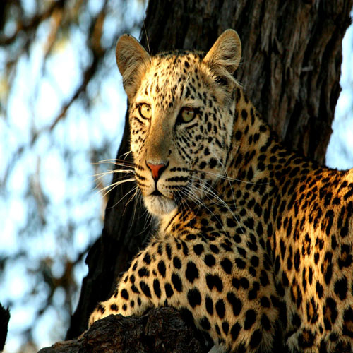
Truly the flagship of the South African national parks, the Kruger is home to an remarkable number of species: 336 trees, 49 fish, 34 amphibians, 114 reptiles, 507 birds and 147 mammals. Man's interaction with the Lowveld surroundings over many centuries - from bushman rock paintings to majestic archaeological sites like Masorini and Thulamela - is very evident in the Kruger National Park. These treasures represent the cultures, persons and events that played a role in the history of the Kruger National Park and are conserved along with the park's natural assets.
