Home :: Indian National Parks :: Sundarbans National Park
Sundarbans National Park
The Sundarbans National Park covers 10,000(ten thousand) km2 of land and water in the Ganges delta. It holds the world's largest area of mangrove forests. A number of rare or endangered species live in the park, including tigers, aquatic mammals, birds and reptiles.

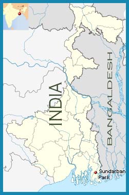
The Sundarbans National Park be positioned south-east of Calcutta in the District of West Bengal (India) and forms part of the Gangetic Delta, which borders on the Bay of Bengal. The Sundarbans National Park, covering some 10,000 (ten Thousand)km2 of mangrove forest and water, is part of the world's largest delta formed from sediments deposited by three (3)great rivers, the Ganges, Brahmaputra and Meghna, which converge on the Bengal Basin.
The whole Sundarbans National Park area is intersected by an intricate network of interconnecting waterways, of which the larger channels are often a kilometre or two(2) in width and run in a north-south direction. These waterways now carry little freshwater as they are mostly cut off from the Ganges(river), the outflow of which has shifted from the Hooghly-Bhagirathi channels progressively eastwards since the Seventeenth(17th) century. This is due to subsidence of the Bengal Basin and a gradual eastward tilting of the overlying crust. In the Indian Sundarbans, the western portion receives some freshwater through the Bhagirathi-Hooghly river system but that portion designated as the tiger reserve is essentially land-locked, its rivers having become almost completely cut off from the main freshwater sources over the last 600(Six hundread) years. Thus, waterways in the tiger reserve are maintained largely by the diurnal tidal flow, the average rise and fall being about 2.15 m on the coast and up to 5.68 m on Sagar Island.

The Sundarbans National Park land is constantly being changed, molded and shaped by the action of the tides, with erosion processes more prominent along estuaries and deposition processes along the banks of inner estuarine waterways influenced by the accelerated discharge of silt from seawater(Bay of Bengal). About half of the Sundarbans National Park is under water and the rest of the landscape is characterized by low-lying alluvial islands and mudbanks, with sandy beaches and dunes along the coast.
The complete mangrove forest extends over an area of 4,262 km2 , of which 2,320 km2 is forest and the rest is water, and is called Sundarban owing to the dominance of the tree species Heritiera fomes , locally known as 'sundari'. This swamp vegetation consists of elements of the Malayan Peninsular and Polynesian regions, together with some Indo-Chinese, Ethiopian and a few of the New World. It is not found elsewhere except in a small part of the Mahanadi and Godaveri deltas to the south-west and the Bay Islands.
The Sundarbans National Park is the only remaining environment in the lower Bengal Basin for a great variety of faunal species. Some of this variety, however, has already been lost owing to the reclamation of the wide transitional belt of habitat for agriculture, combined with the higher salinity resulting partly from the large-scale irrigation schemes in the upper reaches of the Ganges. Species include the Javan rhinoceros and water buffalo, swamp deer and Indian muntjac. Similarly, gharial and narrow-headed softshell turtle became locally extinct within the last 100 years. The tiger population is the largest in India. High population density, relative to the availability of prey, and the relatively high frequency of encounters with local people is probably largely responsible for the notorious man-eating habits of the Sundarbans tiger. The only ungulates are wild boar, main prey species of the tiger, and spotted deer, which is plentiful and often seen in association with rhesus macaque. Aquatic mammals that frequent the tidal waters include the Ganges dolphin, Indo-Pacific humpbacked dolphin, Irrawaddy dolphin and finless porpoise


